Bingham County, ID High Point – 9/14/2024
Trip Stats (Click here)
Summit Elevation: 7,550 ft.
Trip Distance: 9.8 miles
Total Vert: 3,054 ft.
Travel Type: Solo Trail Running
When I was young my dad would sometimes tell me this simple phrase: “Proper Planning Prevents Piss Poor Performance.” I’ve heard it stated less rudely but I think my dad’s 6 P’s really round out the idea that a mountaineer should prepare for even the smallest adventure. Countless articles and stories have been written on how to prepare for a trip into the backcountry. This is not one of those stories.
Much like my Red Butte adventure from a few months prior, my trip to the Blackfoot Benchmark started on a whim. On a warm Saturday in September, after sleeping in too late I decided I was in need of some mountain action in my life. I once again pulled my salty Salomon vest out and loaded it with my first aid-kit, water, and my trusty handgun and headed south. I rolled into the local grocery store in Shelley, ID and bought some candy to fuel my trek. I honestly didn’t feel nervous at all because the hills south of Shelley were my stomping grounds in High School. This misplaced confidence would prove to create discomfort before the afternoon ended.
“Proper planning prevents piss poor performance.”
-Dad
My first act of hubris would take place a few minutes after leaving Shelley. After heading southeast toward Wolverine Canyon I turned too soon down a road I confidently thought was the correct one. I thought I knew the area better than I did and ended up driving 15 minutes onto the Fort Hall reservation before realizing that, contrary to my previous thought, I did not in fact know which road this trail was on. The trail head was one ridge-line to the east. At 4 o’ clock in the afternoon, this should have signaled the end of my adventure and I should have driven home with my ego in check, but where’s the fun in that.
After a quick check of the GPS I found myself on Blackfoot River Road. My second mistake of the day was not realizing how deep into the Blackfoot mountains the Benchmark really was. A few short glances at the map made me think that a quick 15 minute drive out of town would place me at the foot of the mountain. Nay nay! The trailhead would be a 50 minute drive of snaking gravel road into the beautiful but rugged highland desert.

Near 5pm I arrived at the bottom of a small ravine leading up Miner Creek, where I would park my car and begin my trek. There is a gate on the east side of the road that is locked to keep motorized traffic out. The beginning of the hike is on private property but after reading online that the owners were ok with foot traffic, I hopped the fence and started into a jog. The road travels up the drainage for about a mile before it reaches a corral with a camper parked inside. It may be tempting to stay in the ravine, but just to the south of the corral there is a four wheeler trail that will help start your ascent upward.
The next 2 or 3 miles are really uneventful and require little thought but this is where I made my final mistake. there is quite a bit of elevation change between the road and the summit. The four wheeler trail climbs the rolling rangeland, crossing in and out of BLM land through multiple gates. Basically, just keep heading eastward. The day I went there were many cows still out on range. I ask that if you do venture out into the area, please carefully open and close any gate crossings you encounter. If you can’t figure out how to undo/replace a barbed wire dancer gate… maybe badminton would be a better sport for you. But in all seriousness, just remember: it might be recreation for you, but this land is likely someone’s livelihood. Respect it.
After several rolling hills and gate crossings, I passed by/through a couple small aspen groves and then the four wheeler trail took a sharp turn northward. At this point the destination was on my right and it was time to descend down 300 feet to Rawlins Creek before the final summit climb. This is where the adventure turned from easy cow trail to abusive bushwhack. There isn’t any track, so it just turned into the path of least resistance which was often painful in the form of scratches on my legs. Long compression socks and athletic shorts was not the choice for this for this portion of the journey.

After a quick descent, a hop across the small but muddy, cow-stomped creek, and another navigation through aspen deadfall I was looking up the last 900 foot climb the high point. It was here that I had a realization. I was nearly 5 miles of hills from my car, had 37 minutes until sunset, and I still hadn’t reached the summit. Additionally, the thick sagebrush had been ruthless on my legs and it didn’t seem like that was going to change anytime soon. So, I did what any smart mountaineer would do; I sat down on a rock, ate some candy and called my dad. He had been home sick that week and was a willing brain to bounce my concerns off of. I shared that I was a little worried about hiking in the dark by myself in such a secluded place and he basically told me, “you better get moving then.” He cheered me on and told me if I wasn’t near the top in 15 minutes it was probably time to turn around.
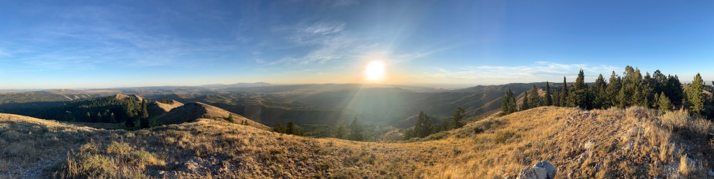
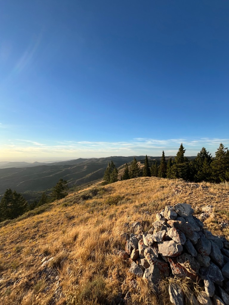
So, I dashed uphill like I never have before. Luckily, the sagebrush broke and I was able to crank out that last half mile in a few short minutes. I was sweaty, scratched up, and a little worried about time, but I made the top. I honestly, wish I had come earlier because the view was absolutely gorgeous from the summit. The Blackfoot mountains rolled in every direction with no sign of civilization in sight. I was left in awe of how much open and untamed land exists in Eastern Idaho.
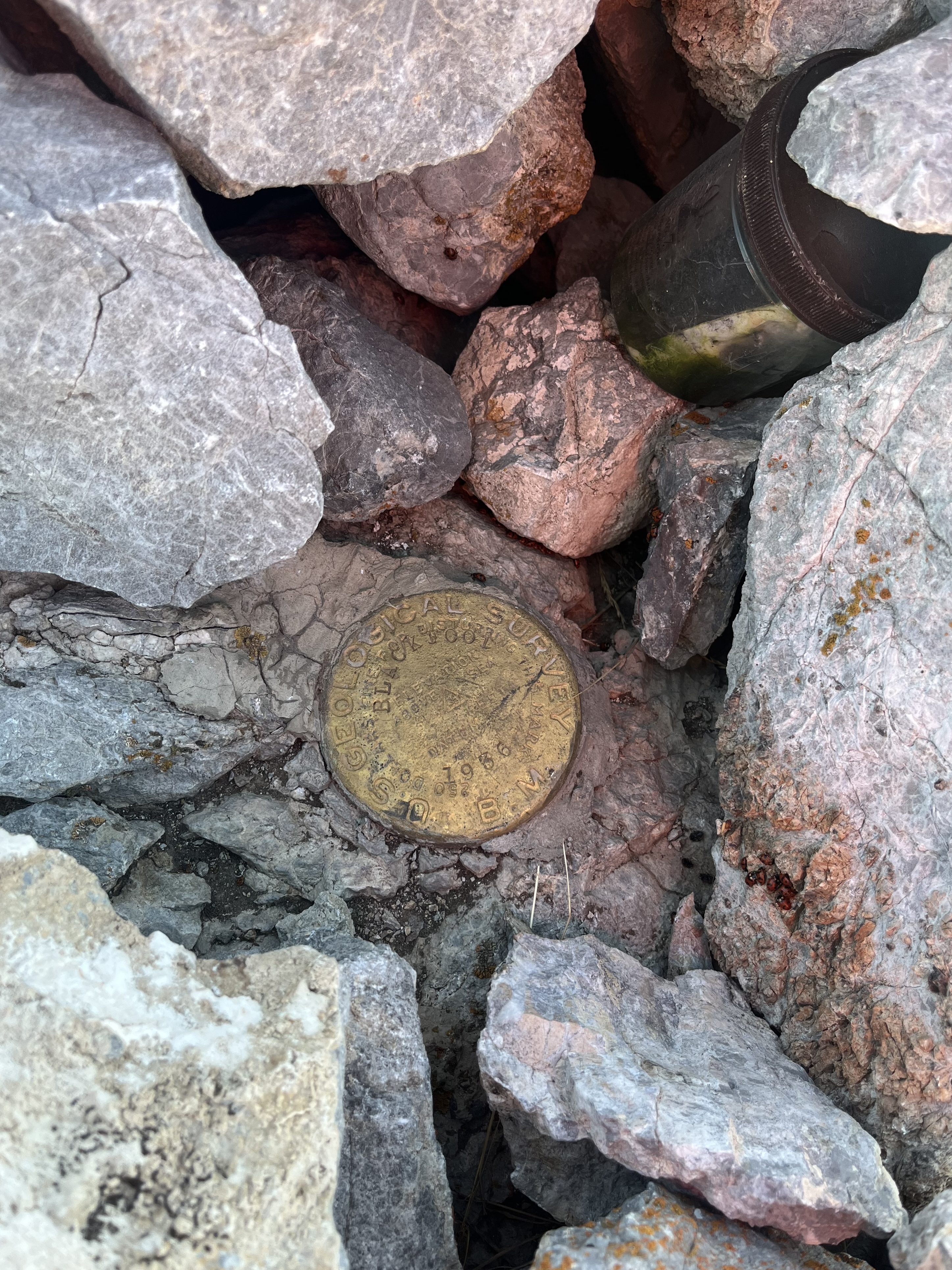
I spent a couple short minutes at the summit signing the register and snapping some sunset photos before dashing down the ridge toward Rawlins Creek once again. I knew at this point there was going to be some hiking in the dark, my goal was to make it back to the four wheeler trail soon enough to mitigate a pitch black bushwack. Other than a couple short slides on loose dirt, the descent was uneventful and fast. I definitely built a sweat making my way back up to the ATV trail but I arrived with plenty of light left. Thus began my sweaty twilight jog back to the car
The fading light of day held in there for a good-long while and helped me to find a rhythm along the trail, but eventually I was left retrieving my headlamp after being startled by a number of curious bovine not far from the fence line . (I’m rather jumpy in the dark.) It was also surprising to realize how much I had climbed on the run in. My pace slowed as I as I worked my way down the long steep path back to miner creek.

Eventually it was nearly pitch black outside and I made it back to the mile long section of road, passing the corral. Not a sound could be heard for miles and it was dead still as I plodded along. At one point, I picked up the pace on the flat road because, in the dead silence, I heard what sounded like a man calmly whistling. I’m pretty sure it was a bird with a strange call but I definitely was going to stick around and find out. Never have I hopped a gate and popped into my car as quick as I did that night.
Had I been a little more prepared with a map, accurate distance, water, proper clothing, and timing, this probably would have been a more enjoyable little mountain to check off the list, but that’s really ok. I think we sometimes need to have low risk days that don’t go smoothly in the mountains because they remind us what’s at stake. I definitely underestimated the Blackfoot Benchmark but it was a good learning experience all-in-all. It reminded me to keep my ego in check, no matter how dry, boring, and accessible the mountain may seem on a map. Maybe someday, a little bit of learned preparation will keep me from a more serious (and possibly life threatening) “piss-poor performance.”

Leave a comment